3D Vision Aided GNSS Real-Time Kinematic Positioning for Autonomous Systems in Urban Canyons
Abstract
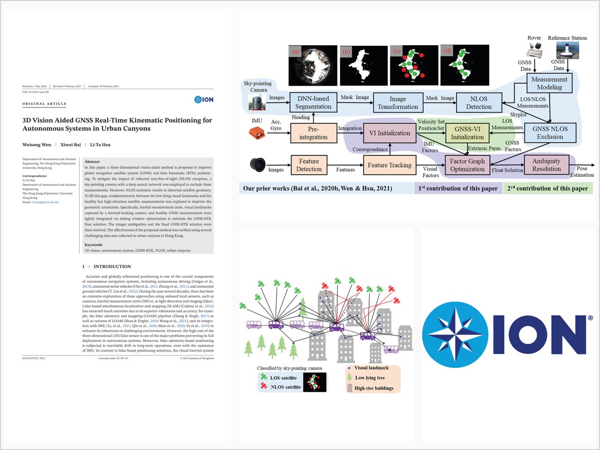
In this paper, a three-dimensional vision-aided method is proposed to improve global navigation satellite system (GNSS) real-time kinematic (RTK) positioning. To mitigate the impact of reflected non-line-of-sight (NLOS) reception, a sky-pointing camera with a deep neural network was employed to exclude these measurements. However, NLOS exclusion results in distorted satellite geometry. To fill this gap, complementarity between the low-lying visual landmarks and the healthy but high-elevation satellite measurements was explored to improve the geometric constraints. Specifically, inertial measurement units, visual landmarks captured by a forward-looking camera, and healthy GNSS measurements were tightly integrated via sliding window optimization to estimate the GNSS-RTK float solution. The integer ambiguities and the fixed GNSS-RTK solution were then resolved. The effectiveness of the proposed method was verified using several challenging data sets collected in urban canyons in Hong Kong. Keywords 3D vision, autonomous system, GNSS-RTK, NLOS, urban canyons
WEN et al. (VINS) is a complementary and cost-effective method for robotics navigation applications. The VINS exhibits several advantages, including size, power assumption, weight, and availability. Many state-of-the-art VINS pipelines have been developed in the past several decades, including filtering-based methods such as Multi-state Constraint Kalman Filter (MSCKF), robust visual inertial odometry (ROVIO) (Bloesch et al., 2015), and Openvins (Geneva et al., 2020). Other research directions include optimization-based VINS pipelines such as the Open Keyframe-based Visual-Inertial SLAM (OKVIS) (Leutenegger et al., 2015), VINS-Mono (Qin et al., 2018), and ORB-SLAM3 (Campos et al., 2021). However, the VINS shares a similar drawback with lidar, namely, that the estimation state is subject to drift over time. Moreover, results from previous studies (Bai et al., 2020a; Bai et al., 2020c) revealed that the urban canyon scenarios introduce additional challenges to the VINS due to excessive movement of objects in the surroundings, unstable illumination, and even stronger motion blur, all of which would enhan
Problem Addressed
Reflected NLOS reception degrades GNSS real-time kinematic positioning in urban canyons, and excluding NLOS measurements distorts satellite geometry, limiting the benefit of exclusion-based approaches.
Key Contributions
- Sky-pointing camera with deep neural network to detect and exclude NLOS measurements
- Exploitation of complementarity between low-lying visual landmarks and healthy high-elevation satellites
- Tight integration of IMU, forward-looking visual landmarks, and healthy GNSS measurements via sliding window optimization
- GNSS-RTK float solution estimation followed by integer ambiguity resolution
Conclusions
The proposed three-dimensional vision-aided method improves GNSS-RTK positioning for autonomous systems in urban canyons. Its effectiveness was verified on several challenging datasets collected in urban canyons in Hong Kong.